


9walks2.download

Guided walks for people who’d like to get back to where they started

© 2018-2025 9walks2.download
About
So what is different?
Rather than expecting you to take our word for it that a route is a suitable one for you, we aim to provide you with the all the information you might need to decide for yourself. To achieve this, we stick to a few rules: • just nine walks in each area • if a new one is added an old one is removed. No choice overload. • for each walk: maps, a slow video (walking speed) and a fast video (driving speed) • all downloads for any one area should fit on a 32GB memory card Those are the basics. The details come next. Of course, reading the instructions is so far outside the boundaries of normal behaviour, it hardly seems worth providing these pages. Just in case, here they are anyway.


Videos
Fast and slow? There are two speeds of video And within the slow category, two qualities. Slow These are shot at walking speed, so a fifteen mile walk really does last for more than five hours. Where else can you get a five hour video in which nothing happens, slowly? They are available for download in two qualities: 1. 384 videos are compressed at a bit rate of 384Kb/s 2. 1.25 videos are compressed at 1.25Mb/s There is an improvement in quality at 1.25, at the cost of a larger (between 3 and 4 times larger) download. Neither form is by any stretch of the imagination HD. If you want an attempt to explain why, click here. Fast These give you the view you might expect if you drove the route at something like motorway speed. They are higher quality at a download size similar to the 384_movies, but last only 6-12 minutes. Because of the rate and degree of change between frames, these can stress the graphics capabilities of some older devices and they may struggle to keep up, resulting in erratic playback. If playback isn’t smooth, try a device with more oomph, or right click and chose “save link as…” to downlaod the whole thing first. A Note of Caution Data may be free and unlimited for most home broadband users nowadays, but it would be wrong not to draw your attention to the size of some of the files you might be downloading. At the extreme, the 1.25 video of a 6 hour route will be around 3 GB. Having made a purchase, you get 3 attempts at making a download of each individual file, over a period of 7 days (2 attempts and 1 day for the freebies). If it has all gone belly-up, 3 times, please use the form on the CONTACT page or email us. Alternatively, you could use the 384 version, for a smaller (but fuzzier) download, or just download the maps on their own in one bundle.


Maps
But aren’t maps meant to be confusing?
Ultimately, any time spent in becoming familiar with Ordnance
Survey maps is time well spent, but the learning process can
have its frustrations, especially if there is nobody on hand to
consult.
The maps used here are designed to overcome at least some
of those frustrations by including extra detail where it may
help and leaving out detail where it may only confuse.
Hopefully, after nine days out with these maps, you will be
confident enough to take off with an OS map and to devise
new routes for yourself.
There are a few major differences from regular maps.
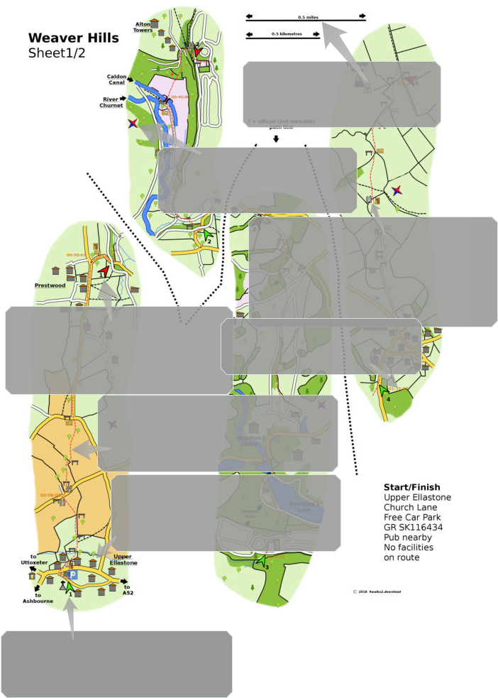
The Sections
If you enlarge the map on the right, you will see that it is
divided up into four sections.
You will always be walking from the bottom to the top - no
more turning the map in your hand trying to read upside-down
writing and worrying where north is. It doesn’t really matter
where north is (having said that, there is a symbol for each
section to tell you where it is) because, for the most part, this
isn’t the kind of country that requires compass-work.
You start at the beginning of section 1 (all sections start at the
numbered green arrow), walk to the red arrow, then return to
the next green arrow at the bottom of the next section and
repeat. When there are no more arrows, you should be seeing
your car - if you reached the start by bus, well done, but you
probably won’t be getting your ride back for a week, if ever.
The Times
At various points along the way you will see a set of numbers
(01:23:55) in orange. These are times which correspond to the
slow video (not the fast video).
They may be at points where the choice of where to go next is
confusing, or at natural break points (you know - coffee,
snack, natural break).
They are also a useful guide as to how far through the walk
you are, since there are no references to distance.
The Distances
You may have noticed some vagueness about the length of the
routes (use of “approx” on the maps, etc.). You can get a
better idea of how long/short and easy/hard they are from the
times and videos.
If you want to have a number of miles/km to impress friends
with, take the one on the map and add 25% - that’s what
everyone else does. Tell them you ran it, backwards, wearing
clogs. What? You think they might check up on you? Are those
really friends?
Contours
There aren’t any. Assume there will be slopes - some up, some
down. If and when you arrive back at the start, the two will
have exactly balanced out. Tell yourself this on the steepest
parts. Only the steepest parts are indicated, along with any
steps. The video will tell you more.
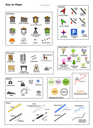
Key
The maps contain many different symbols. A key to what they
represent can be downloaded (.pdf) here.
Files
When you download the maps, they will be in a zipped folder.
Unzip this and you will have the pages (A4 size) of the map, in
both .pdf and .jpg form. There is no difference other than the
file type.
Other Maps
Having attempted to convince you that these guides give you
all the necessary information in order to complete a walk, it’s
still a good idea to buy the appropriate OS map. They are
wonderful works produced by wonderful people which give you
a much bigger picture of what’s around you than our
necessarily narrow maps. They are also great for swatting flies.


9walks2.download

Guided walks for people who’d like to get back to where they started

©2018-2025 9walks2.download
About
So what’s different?
Rather than expecting you to take our word for it that a route is a suitable one for you, wouldn’t it be better to provide you with the information to decide for yourself? To achieve this, we stick to a few rules: • just nine walks in each area - if a new one is added an old one is removed. No choice overload • for each walk: maps , a slow (walking speed) video and a fast (driving speed) video • all downloads for any one area should fit on a 32GB memory card Those are the basics. The details come next. Of course, reading the instructions is so far outside the boundaries of normal behaviour, it hardly seems worth providing these pages. Just in case, here they are anyway.


Maps
Aren’t maps meant to confuse?
Ultimately, time spent in becoming
familiar with Ordnance Survey maps is
time well spent, but the learning process
can have its frustrations, especially when
there is no one on hand to consult.
The maps used here attempt to reduce at
least some of those frustrations by
including extra detail where it may help
and leaving out detail where it may only
confuse.
Hopefully, after nine days out with these
maps, you’ll be happy to take off with an
OS map and to devise your own routes.
There are a few major differences from
regular maps:
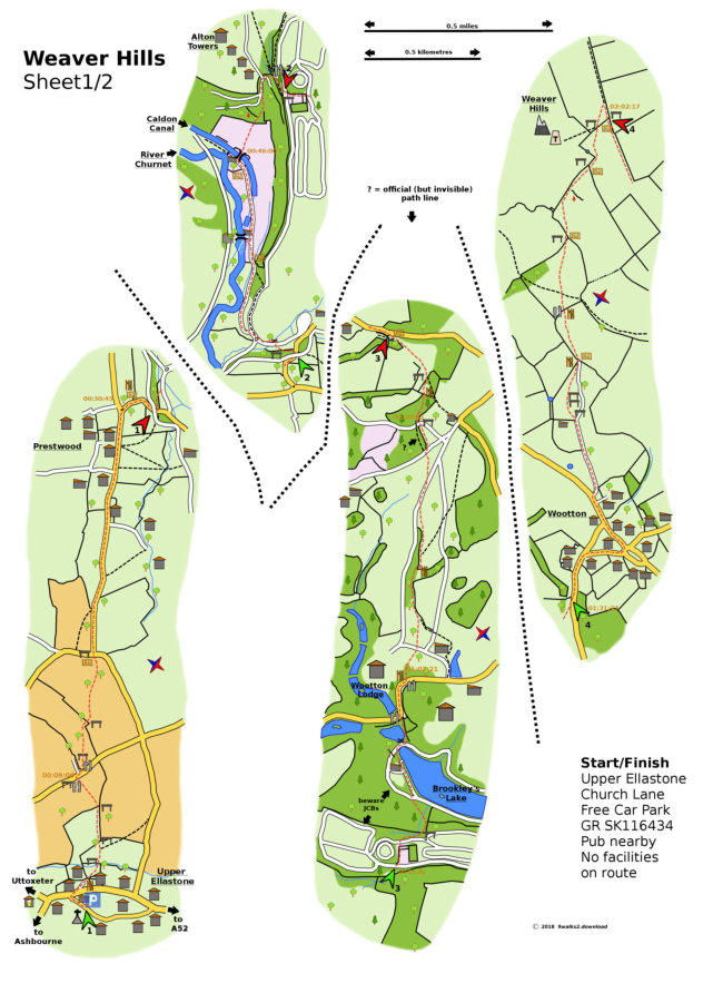
The Sections
If you enlarge the sample map here, you
will see that it is divided up into four
sections

You will always be walking from bottom to
top - no more turning the maps in your
hand whilst trying to read upside-down
writing and wondering where north is. It
doesn’t really matter where north is
(although there is a symbol on each
section to tell you), because for the most
part this isn’t the kind of country that
requires compass-work.
You start at the beginning of section 1 (all
sections begin at a numbered green
arrow), walk up to the red arrow, then
return to the next green arrow at the
bottom of the next section and repeat.
When there are no more arrows, you
should be seeing your car - if you reached
the start by bus, well done you but you
probably won’t be getting your ride back
for a week.
On screen or paper, no more spinning the
map around and trying to read upside-
down writing.
The Times
At various points you will see a set of
numbers (01:24:54) in orange. These are
times which correspond to the slow (not
the fast) video. They may be at points
where the choice of where to go next is
confusing, or at natural break points (you
know - coffee, snack, natural break).
They are also a handy guide as to how far
through the walk you are, since there are
no references to distance.
The Distances
You may have noticed some vagueness
about the length of the routes (use of
“approx” on the maps, etc.). You can get
a better idea of how long/short and
easy/hard they are from the times and
the videos.
If you want to have a number of miles/km
to impress friends with, take the one on
the map and add 25% - that’s what
everyone else does. Tell them you ran it,
backwards, wearing clogs. What? You
think they might check up on you? Are
those really friends?
Contours
There aren’t any. Assume there will be
slopes - some up, some down. If and
when you arrive back at the start, the two
will have exactly balanced out. Tell
yourself this on the steepest parts. Only
the steepest parts are indicated, along
with any steps. The video will tell you
more.
The maps contain many symbols. A key to
what they represent can be downloaded
as a .pdf here:
Files
When you download the maps, they will
be in a zipped folder. Unzip this and you
will have the pages (A4 size) of the map,
in both .jpg and .pdf form. There is no
difference other than the file type.
Other Maps
Having attempted to convince you that
these guides give you all the necessary
information in order to complete a walk,
it’s still a good idea to buy the appropriate
OS map. They are wonderful works
produced by wonderful people which give
you a much bigger picture of what’s
around you than our necessarily narrow
maps. They also make great fly-swatters.

Videos
Fast and slow?


A Note Of Caution
As you may be viewing this on a phone
and you may be on a plan with limited
data, please be aware that the videos
included in the bundle for each route are
large downloads. The size of the
downloads can be viewed in a pop-up for
each route, but at the extreme, a 1.25
video of a 6 hour route will be close to
3GB.
If you choose to purchase using your
phone, it would still be better to download
just the maps and wait until you are at
home, with a laptop or desktop and a
reliable, unlimited connection, to do the
rest.
You do have 7 days and 3 attempts at
each download, except for the freebies,
which are 1 day and 2 attempts.
If problems persist, please contact us
using the details on the CONTACT page.
Alternatively, you can purchase all of the
maps for each area in one bundle (about
50MB when all 9 are ready). Scroll down
to the bottom of the walks listing for this
option.
There are two speeds of video and, within
the slow category, two qualities.
Slow
These are shot at walking speed, so for a
fifteen mile route, the video really does
last for more than five hours. Where else
can you get a five hour video where
nothing happens - slowly?
They come in two qualities:
384 videos are compressed at a bit rate of
384Kb/s
1.25 videos are compressed at 1.25Mb/s
There is an improvement in clarity at 1.25
at the expense of a larger (3 to 4 times
larger) download.
Neither is by any stretch of the
imagination HD quality - if you would like
an attempt at an explanation as to why:
Fast
These give you a view you might expect if
you drove the route at something like
motorway speed.
They are higher quality than than their
slow counterparts at a download size
similar to the 384s, but last only 6-12
minutes.
Because the rate and degree of change
from frame to frame is so great, these can
stress the graphics capabilities of some
older devices, resulting in erratic playback.
If this is the case, it may help to download
the whole sample clip first with this button


9walks2.download

Guided walks for people who’d like to get back to where they started

© 2018-2025 9walks2.download
About
So what’s different?
Rather than expecting you to take our word for it that a route is a suitable one for you, we aim to provide you with the all the information you might need to decide for yourself. To achieve this, we stick to a few rules: • just nine walks in each area - if a new one is added an old one is removed. No choice overload. • for each walk: maps, a slow video (walking speed) and a fast video (driving speed) • all downloads for any one area should fit on a 32GB memory card Those are the basics. The details come next. Of course, reading the instructions is so far outside the boundaries of normal behaviour, it hardly seems worth providing these pages. Just in case, here they are anyway.

Videos
Fast and slow?
There are two speeds of video
And within the slow category, two qualities.
Slow
These are shot at walking speed, so a fifteen mile walk really
does last for more than five hours. Where else can you get a
five hour video in which nothing happens and takes so long to do it?
They are available for download in two qualities:
1.
384 videos are compressed at a bit rate of 384Kb/s
2.
1.25 videos are compressed at 1.25Mb/s
There is an improvement in quality at 1.25, at the cost of
a larger (between 3 and 4 times larger) download.
Neither form is by any stretch of the imagination HD.
If you want an attempt to explain why, click here.
Fast
These give you the view you might expect if you drove the
route at something like motorway speed.
They are higher quality at a download size similar to
the 384_movies, but last only 6-12 minutes.
Because of the rate and degree of change between frames, these
can stress the graphics capabilities of some older devices and they may struggle to keep up, resulting in
erratic playback.
If playback isn’t smooth, try a device with more oomph, or right-click and chose “save link as….” to download
the whole clip first.
A Note Of Caution
Data may be free and unlimited for most home broadband users nowadays, but it would be wrong not to
draw your attention to the size of some of the files you might be downloading. At the extreme, the
1.25 video of a 6 hour route will be around 3 GB.
Having made a purchase, you get 3 attempts at making a download of each individual file, over a period of
7 days (2 attempts and 1 day for the freebies). If it has all gone belly-up, 3 times, please CONTACT US.
Alternatively, you could use the 384 version, for a smaller (but fuzzier) download, or just download the
maps on their own in one bundle.


Ultimately, any time spent in becoming familiar with Ordnance Survey maps is time well spent, but the learning process can have
its frustrations, especially if there is nobody on hand to consult.
The maps used here are designed to overcome at least some of those frustrations by including extra detail where it may help and
leaving out detail where it may only confuse.
Hopefully, after nine days out with these maps, you will be confident enough to take off with an OS map and to devise new routes
for yourself.
There are a few major differences from regular maps.
The Sections
If you enlarge the map on the right, you will see that it is divided up into four sections.
You will always be walking from the bottom to the top - no more turning the map in your hand trying to
read upside-down writing and worrying where north is. It doesn’t really matter where north is (having
said that, there is a symbol for each section to tell you where it is) because,for the most part, this isn’t
the kind of country that requires compass-work.
You start at the beginning of section 1 (all sections start at the numbered green arrow), walk to the red
arrow, then return to the next green arrow at the bottom of the next section and repeat. When there are
no more arrows, you should be seeing your car - if you reached the start by bus, well done, but you
probably won’t be getting your ride back for a week, if ever.
The Times
At various points along the way you will see a set of numbers (01:23:55) in orange. These are times which correspond to the slow
video (not the fast video).
They may be at points where the choice of where to go next is confusing, or at natural break points (you know - coffee, snack,
natural break).
They are also a useful guide as to how far through the walk you are, since there are no references to distance.
The Distances
You may have noticed some vagueness about the length of the routes (use of “approx” on the maps, etc.). You can get a better
idea of how long/short and easy/hard they are from the times and videos.
If you want to have a number of miles/km to impress friends with, take the one on the map and add 25% - that’s what everyone
else does. Tell them you ran it, backwards, wearing clogs. What? You think they might check up on you? Are those really friends?
Contours
There aren’t any. Assume there will be slopes - some up, some down. If and when you arrive back at the start, the two will have
exactly balanced out. Tell yourself this repeatedly on the steepest parts. Only the steepest parts are indicated, along with any
steps. The video will tell you more.
Key
The maps contain many different symbols. A key to what they represent can be downloaded (.pdf) here.
Files
When you download the maps, they will be in a zipped folder. Unzip this and you will have the pages (A4 size) of the map, in both
.pdf and .jpg form. There is no difference other than the file type.
Other Maps
Having attempted to convince you that these guides give you all the necessary information in order to complete a walk, it’s still a
good idea to buy the appropriate OS map. They are wonderful works produced by wonderful people and are also great for swatting
flies.

Maps
But aren’t maps meant to be confusing?